Sunday, November 30, 2014

Sedona, AZ 11/19/14-12/1/14

Sedona was planned as a chill and hang point.  But, as has proved true before, we always find cool things to see and do.

  • We hiked the Devil's Bridge
  • Teri took some classes at the park on how to post a map and has since done that (as in check out the tab button at the top of the blog entitled Interactive maps).  Also, captions on the pictures are now included when you expand the thumbnail, however, sort of small when you just view on the blog.  One of those you can't have your cake and eat it too.
  • We had a wonderful Thanksgiving dinner joined by Jean and John (new RV friends)
  • We washed and waxed our rig (not so fun, but part of this adventure)
  • We toured the eclectic/ antique shops of Cottonwood ( a lot of fun) and
  • We hiked some really cool Indian ruins and on our last day.
  • Never forget the eats.... (after Thanksgiving) we smoked a Turkey and we also visited Simon's hot dogs.  We had been to Simon's before and our return visit is something we were looking forward to.   
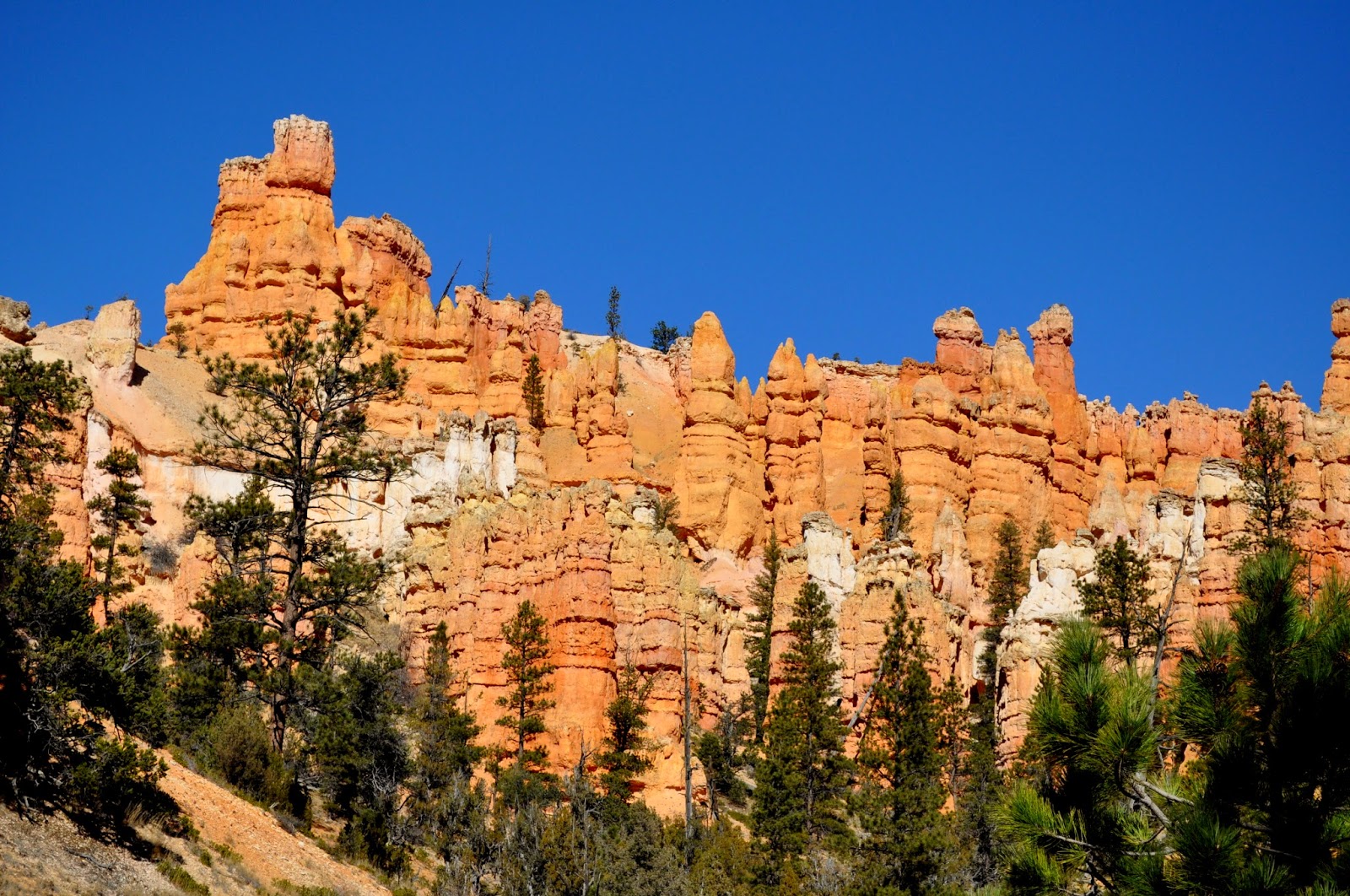
  • Sedona, while planned as a way point, it turned out to be somewhere that we did so much more than we planned.

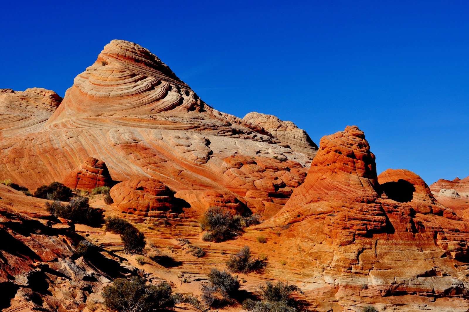
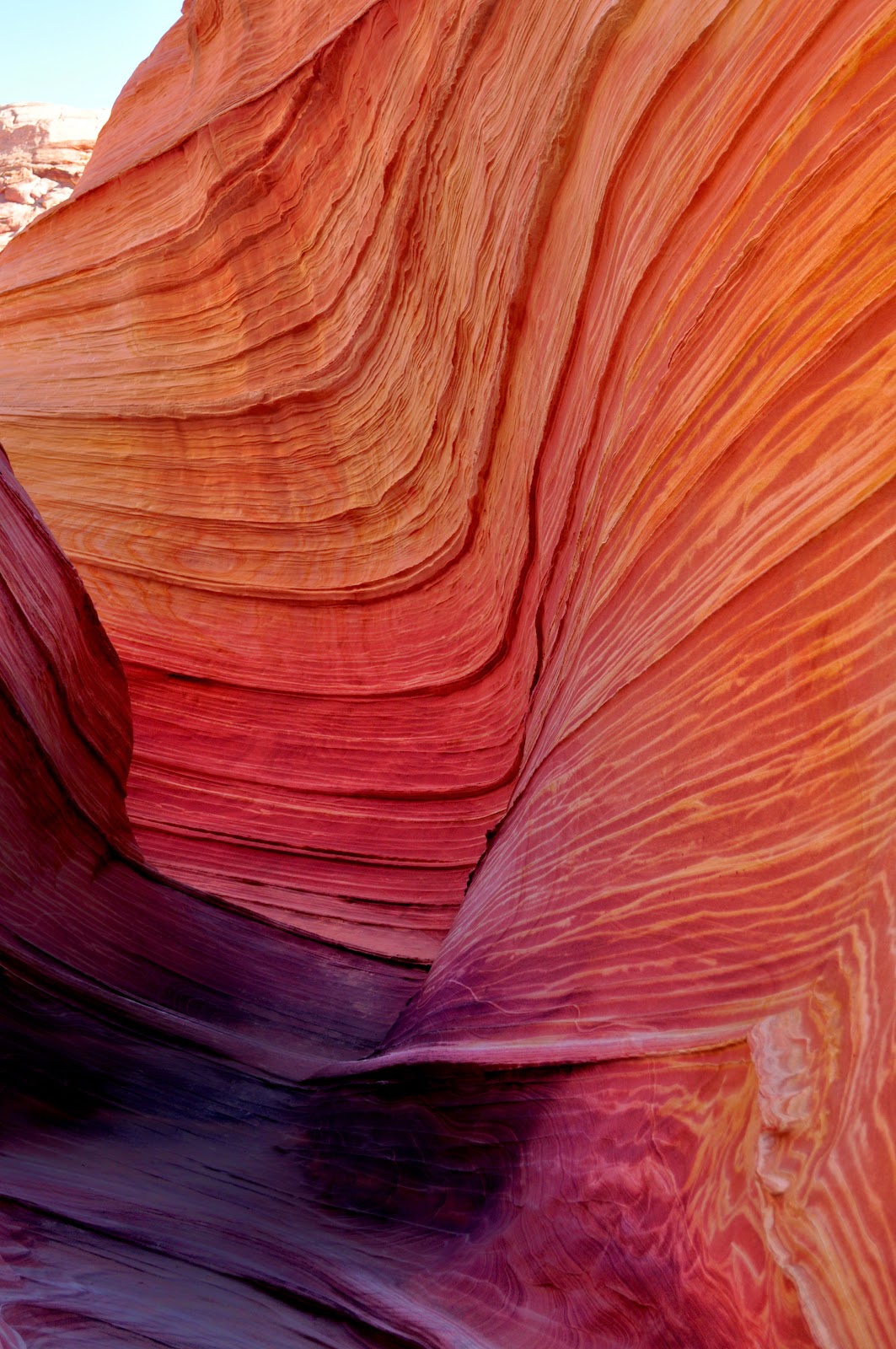
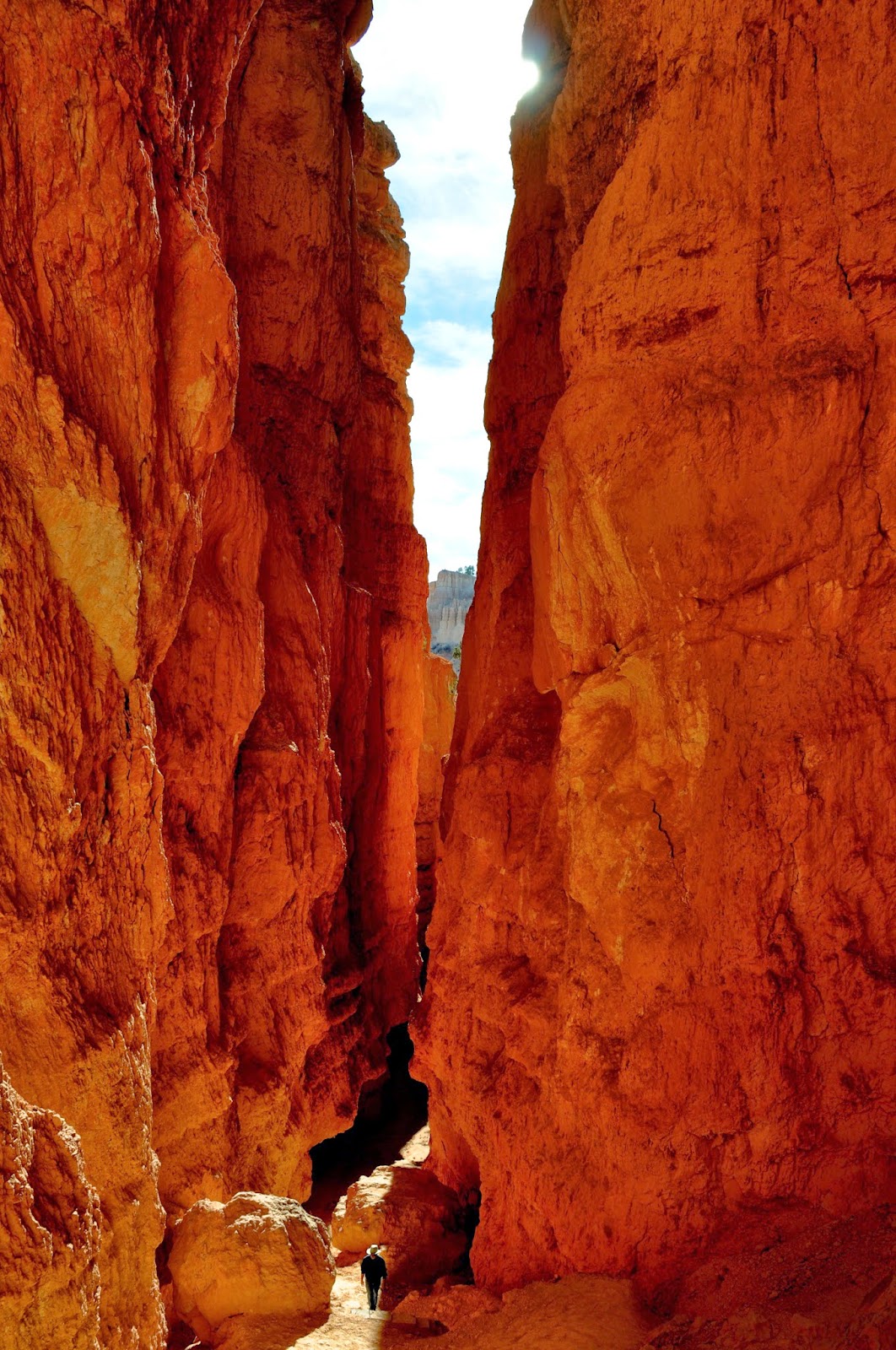
Devil' Bridge:  So past Teri's comfort zone, as she does not like heights.  But we both pushed on and were glad that we did.  To see what she pushed though (1/4 mile of this) check on this link Devils Bridge steps.  Teri was too into the task at hand to take pictures of the climb.  Devil's Bridge is the largest natural sandstone arch in the Sedona area. While beautiful, for those not liking heights, it is an accomplishment, beautiful (and worth it), yet a bit scary.

Our trip into historic Cottonwood was a lot of fun.  We went through many combination eclectic/antique shops.  The things we saw!  We had a nice lunch and this adventure entertained us for hours.

We took one day to see the Palaki Ruins and the Honanki Ruins.  Getting there involved 20 miles of unpaved roads out and back.  This is not Bob's favorite thing to do (the dirt roads) but he was a trooper and wow, what cool ruins we saw.

We hiked the areas of two well preserved Indian Ruins.  The Palaki Ruins are an area that was inhabited by many civilizations. Some of the rock scratchings date back as far as 6,000 BCE, and no that is not a typo.  The Sinagua people, most represented, are believed to have been here 1100-1400 CE.  From the Palaki Ruins we continued up another 7 plus miles of dirt roads to reach the Honanki Ruins.  The pictographs in the caves here date back to about 2000BCE.  The Sinagua lived here from 900-1300CE. This sight also has many pictographs done by both the Yavapai and the Apache from 1400-1875 CE.  We found it amazing that these treasures have survived for so long for all of us to enjoy.

We can not mention Sedona without mentioning Simon's hotdogs.  We first met Simon about 4 years ago.  He is the nicest guy.  Teri loves his Colombian dog which consists of a beef hot dog, special sauce, pineapple, cheese and potato chips on top.  Simon tells us in Columbia, this dog also has a quail's egg on top.  Bob is a Wunderhund dog kind of guy.  We were treated to Simon's twice while we were here.  His menu is fun: Simons menu

We are off to Winter in Mesa, AZ until May 1!  Like wow, a very long time for us.  Our posts may be fewer, but hang in there.  While in AZ we have some cool trips planned, like stay tuned.  :-)


Wednesday, November 19, 2014

The Wave-North Coyote Buttes, Utah 11/18/14

We did it, the Wave Hike.  What a wonderful day.  The weather was perfect too, around 30 when we began, 50's on the way back and NO wind.  We began with seeing about 8 deer, out for breakfast and there were a few small patches of snow on the ground.  The hike is a little over 6 miles out and back, 1100 foot of elevation gain and a mixture of sand, stone and hiking over buttes (actual hiking was about 90 minutes each direction).  The 20 total that were there for the day was a good international mix- 4 from Japan, 2 from Brazil, 1 from South Korea, 2 from Utah, us and the online lottery people, many that we met but did not know as well.  By the time we left the actual Wave (which is about 2 acres), it was getting sort of crowded.  Glad we got out early for this hike.

The Hike to the Wave is not a trail.  The rangers give you about 10 very small landmark pictures to guide you out and back (5 for each direction).  Knowing the general direction is not difficult, the pictures help to guide you over the 'easier' buttes, however, as some of the buttes are pretty steep, and you can't see the other side's decent until you get to the top. One might think that this is all about the Wave, but the hike out was absolutely beautiful too and with the limit on people, so quiet and peaceful. And the Wave....like wow, as you will see below.

The Paper that made it all possible
One of many Deer we saw starting out
The View As We Hike to the Wave
 The View As We Hike to the Wave
The View As We Hike to the Wave
 This Butte is easier than it looks to get over
it was almost like Nature's staircase
The View As We Hike to the Wave
 Looking down at one of the many buttes
we need to climb down
The View As We Hike to the Wave
Hiking across the 'bread rolls'
The View As We Hike to the Wave
We made it!  Bob at the Wave
Teri at the Wave

 The Wave
 The Wave
 The Wave
Teri at the Wave
Bob at the Wave

The Wave
The Wave
 The Wave
 The Wave
The Wave 


Monday, November 17, 2014

Kanab, Utah 11/7/14 - 11/17/14


Kanab, Utah was our lottery location for the Wave hike and also our Bobtail launching point for other destinations.  As I begin this blog (11/11/14), we have been to the lottery 3 mornings so far with no success.  Hopefully as I finish up writing this blog and actually post we will be shouting yahoo (having won the hike lottery) and if not, it has forced us to be up and out the door each morning to do other things. 

The Wave is a hike that only 20 people are allowed per day to do.  There is an online lottery (pulled 3 months in advance for 10 people)and a daily, in person lottery at 9 am sharp for an additional 10.  The daily lottery so far has had from 50 -100 people hoping to be one of the lucky ones for those remaining 10 slots.

Bobtailing- plopping yourself down to camp in one spot and circling out for other adventures from that spot.  The diameter of our bobtailing adventures on this trip was approximately 100 miles.  Tiger really appreciates this type of travel as he gets to stay off the roads and chill back at the rig. First up, was Bryce Canyon.

Bryce Canyon is another location that we will be back to for sure.  The park is filled with numerous Hoodoos.  And we quickly saw that once you have seen one Hoodoo, you for sure have not seen them all.  Hoodoos, as opposed to spires, typically have variable thicknesses, and have a more totem pole likeness than spires.  Multiple Hoodoos we thought resembled beautiful sand castles.  One thing is for certain, they are all unique and fun to look at and Bryce Canyon has a wonderland full.  Bryce was a little over an hours dive from Kanab and the park for Winter closes at 4.  Even with the short time we still had time to hike both the Navajo Loop and the Queen's Garden Trail and also do the 18 mile scenic vehicle tour with its numerous turnouts and mini trails.  Like most of the National Parks we have been to, deer seem to be commonly seen.  There are more trails we are interested in that we will save for a return trip.

Pipe Spring National Monument is actually located in Arizona and is approximately 20 miles from Kanab.  This Monument located out by itself, surrounded by the Paiute Indian Reservation, was a surprisingly interesting destination.   Our young guides were all members of the Paiute Nation and were both cheerful and knowledgeable.  One Thousand years ago Paiutes, Utes and Navajo Indians roamed the area and benefited from the Pipe Springs.  We learned of a lot of conflicts, even among the various tribes, including the Navajo's stealing the Paiute's women and children and selling them into the slave trade. In 1858  Jacob Hamblin, a Latter Day Saints (LDS, aka Mormon) missionary, came across this spring and named it Pipe Springs.  He realized what a great find this oasis was and shared the information with other members of the church.  In the 1860's James Whitmore, a member of the LDS brought cattle to this spring and eventually would establish a large 'tithing' cattle ranch, utilizing water from the spring.  In 1866, cattle were stolen, the Pipe Springs were raided and Whitmore was killed by Indians (indecision still exists as to which tribe killed Whitmore).   In 1872, Brigham Young, the Leader of the Church of Latter Day Saints ordered that a fort be built to protect the spring, and a fort was erected on top of the spring.  A Bishop from a nearby LDS Church, Anson Winsor, was hired to run the operation for the church and the fort quickly took on the name Winsor Castle, after Anson Winsor.  This isolated outpost also served as a way station for LDS traveling along what was called the Honeymoon trail (Married LDS heading to St. George, UT to have their marriages sealed in the temple traveled this trail).  It also served as a refuge for Polygamist wives during the 1880's and 1890's when Polygamist were being arrested and jailed.   Besides raising and tithing cattle the fort made and exported large quantities of butter and cheese all in support of the LDS church.  The church eventually lost the property to the US government by means of the Edmunds-Tucker Act Edmund Tuckers Act.  This act dis-incorporated the LDS church, based upon the fact that they fostered polygamy.  The Mormons not only took the water from the Indians, but the grazing of the cattle took out other wildlife that the Indians depended on such as deer.  The interviews of decedents were interesting to hear - The 'white man' expressed the find and conquer the water attitude and the Indians shared their belief that the water belongs to none and we are all just caretakers of the water.  Once again, we experienced more history that we were unaware of prior to this visit.  Note, that for many years, the National Parks only told the LDS version of the Springs.  The National Parks has made a big attempt to now tell all sides, without bias, of the story which is refreshing.

Next up was Coral Pink Sand Dunes State Park.  We drug our feet in the sand (you can not say hiked).  But it was fun and the area was beautiful.  The dunes are formed from pink-colored Navajo Sandstone that surrounds the park.  The dunes are estimated to be between 10,000 and 15,000 years old.  The total park includes 3,370 acres and also protects the Coral Pink Sand Dunes Tiger Beetle, found no where else in the world.  While we did not see one, we are all about preservation.  The beetle

The Grand Canyon National Park, North Rim is one of the very few National Parks where we have seen almost no wildlife.  Maybe we were too late in the season.   The road into the park is long and lonely (or at least it is in November).  Of special note was a meadow that seemed to go on forever, well at least for over 15 miles.  But once again, no wildlife was in the meadow.  But the drive was quite and peaceful and enjoyable.  November is late to enter the North Rim and almost everything is shut down, including many roads.  But for the areas we visited we got a good feel for the park, mainly that it is so very different than the South Rim.  At a much higher elevation, there are lots of pines and birch trees.  And for the short time we were there, we could see that the infrastructure for tourists was much less than the South Rim, as well.  While we saw a few other people, it was a quite, tranquil and enjoyable experience.  This park too had already gotten snow for the year.  We hear that the North Rim, due to snow, will close in about 2 weeks.

Vermillion Cliffs National Monument has at least 3 claims to fame- the beautiful cliffs, a release site for the California Condor breeding programs and the start of the infamous Wave hike.  The day we were there we learned of one more claim to fame.....incredible winds, as the winds were blowing so hard we took all our pictures from within our truck.  We did this trip on a very poor dirt road, but the sites were wonderful and we were glad that we persevered.  The cliffs are beautiful, more so than the pictures show.  We had hoped we might spot a Condor, but did not have luck in this regard.  We were, however, well rewarded with some views we did not expect.  Hope you enjoy the pictures of those views.  Note, if you are ever in this area the end of September, the new Condors are released at that time and that release is open to the public.

Little Hollywood?  Yes that is what Kanab was called in the day when westerns were popular and the movie business was a big part of the economy of Kanab.  We spoke with a long time resident of the town at a small fuel station.  She told us about when her boys would go to the set and watch the filming of Daniel Boone and when many of the towns people played back up parts of Indians on horseback.  The Parry Lodge was built for cast and crews and opened in 1931.  In the day over 100 featured films were shot here as well as old weekly favorites like Lassie, Gunsmoke and the Lone Ranger. Today the Parry Lodge provides rest for travelers, most visiting nature.  The Parry Lodge website has a good list of the shows and movies that have been shot here.  Little Hollywood filming  The town has a small museum where they have tried to preserve some of the movie sets.  The sets in the pictures below are constructed of foam, some  of cardboard.  The maintenance of this outdoor museum must be quite difficult.  More information on the filming can be watched at this short clip http://www.littlehollywoodmuseum.org/virtual-docent.html

Kodachrome State Park, UT was our next day's venture.  And yes the song kept haunting our brains

....Kodachrome, they give us those nice bright colors, gives those greens of summer, they make you think that all the world's a sunny day.  Well I've got a Nikon camera, I love to take photographs, So Mama don't take my Kodachrome away....

Anyway, we started our Kodachrome day by hiking the Mossy Cave Trail that is on the northern corner of Bryce Canyon.  This is an easy trail, that looks to be spectacular in winter when the cave is full of icicles.  While it was a nice walk, the weather was not quite that cold yet (for icicles).  Kodachrome State Park, while it has hoodoos, it also has 67 monolithic stone spires, or sedimentary pipes within the park.  Geologists are unsure today of the exact origin of these pipes.  There are at least three geologic theories.  Those interested can read more at Kodachrome State Park Brochure The pipes are markedly different than the other hoodoos in the area.  In addition to the pipes, the park has an abundance of color in the surrounding rock, giving way to its name Kodachrome.  While here we hiked the Angel's Palace and also the Shakespeare Trails.  The Angel's Palace took us to the top of the park and provided a wonderful overview of the types of formations as well as a 360 degree view of the entire park.  The Shakespeare Trail took us to the park's largest Arch, Shakespeare Arch.  From Kodachrome State Park we were off for a drive through The Grand Staircase-Escalante National Monument. We drove all the way to the town of Escalante where we had hoped to have a late lunch.  Unfortunately, this time of year, the town comes close to being a ghost town.  No worries, as the drive was lovely.

Day 8 (11/16/14) of the 'Wave' lottery and no luck.  The weather is getting cold, and we are watching closely both our rig and also for the hiking conditions (like in the 30's, which is OK if it is not windy). Doing the on-line lottery the chances are like 5% or less we have heard, which is part of why we have been so persistent.   Today, we decided to give the lottery two more days.  And after 2 days, if not successful, who knows what we may decide.

Waiting, continuing to hope on the lottery for the Wave has keep us hiking, aka exercise, and the covering of a lot of miles.  Our next up adventure was Zion, the East end of the park which we did a couple of days.  We hiked the Zion East Rim trail to Jolly Gulch and also got to see the Checkerboard Mesa there.  Beautiful.  We also hiked a some what unknown area, like no trail, called Many Pools.  Many Pools was a bit of a rock scramble, but unusual and worth the effort.  The day we hiked Many Pools we also were surprised with Long Horned sheep, totally unexpected and so much closer than when we got to view them them in NV.  The two in the pictures below were like within 20 Feet of us.  We also saw about ten more up on the hillside.  A very exciting day for sure.

Day 9 (11/17/14) of the 'Wave' lottery and WE WON!!!!!  The long awaited and hoped for Wave hike we will do tomorrow.  No real trail, but some GPS coordinates and explanations from the Ranger.  We will start our hike at 9am (after an hour drive from here on a dirt road).  It should be up to about 35 degrees when we start the hike and may even reach 50 before we get back.  The biggest blessing is 5 MPH winds.  Some of the days that we lost the lottery, the winds were up over 40 MPH.  Not a lot of fun in a sandy environment, that is out in the open.  So in a way, we figure we won the lottery twice.....first the Wave hike and second getting to do it with little wind.

 Bryce Canyon, UT
The Queen's Garden
Bryce Canyon, UT
The Queen's Garden
Bryce Canyon, UT
 The Queen's Garden
Bryce Canyon, UT
The Queen's Garden
Bryce Canyon, UT
The Queen's Garden
Bryce Canyon, UT
 The Queen's Garden
Bryce Canyon, UT
The Navajo Loop
Bryce Canyon
 Bryce Canyon
 Bryce Canyon
Bryce Canyon
 Bryce Canyon
Bryce Canyon
 Mule Deer
Bryce Canyon
 Mule Deer
Bryce Canyon
 Mule Deer
Bryce Canyon
Windsor Castle-
Pipe Spring National Monument
Windsor Castle-
Pipe Spring National Monument
 Windsor Castle-
Pipe Spring National Monument
Block Construction, Windsor Castle-
Pipe Spring National Monument
 Windsor Castle Resident-
Pipe Spring National Monument
Papoose Cradle (Paiute)
Love the baby head sunscreen
Pipe Spring National Monument
 Coral Pink Sand Dunes State Park, UT
 Coral Pink Sand Dunes State Park, UT
 Coral Pink Sand Dunes State Park, UT
Movie Trivia
The Sand Up Close
Coral Pink Sand Dunes State Park, UT
 Grand Canyon National Park North Rim
 Grand Canyon National Park North Rim
 Grand Canyon National Park North Rim
 Grand Canyon National Park North Rim
 Grand Canyon National Park North Rim
 Grand Canyon National Park North Rim
This meadow leading into the park
was over 15 miles in length
 Vermillion Cliffs, AZ
 Vermillion Cliffs, AZ
A California Condor Release site
We didn't get to see any but thought
this was a great representation of their size
Vermillion Cliffs, AZ
One Little Indian movie set
Little Hollywood, Kanab, UT
The Outlaw Josey Wales movie set
Little Hollywood, Kanab, UT
 Trailhead Mossy Cave
North end Bryce Canyon
 Monolithic Pipe
Kodachrome State Park, UT
Monolithic Pipe
Kodachrome State Park, UT
 Kodachrome State Park, UT
Shakespeare Arch
Kodachrome State Park, UT
Top Stair of the Grand Staircase-
Escalante National Monument
Buffalo along road
East Entrance Zion National Park
Checkerboard Mesa
Zion National Park, East Entrance
Zion National Park
East Rim Trail
Zion National Park
East Rim Trail
Zion National Park
East Rim Trail
Zion National Park
East End
Zion National ParkEast End,
Many Pools Trail
Zion National ParkEast End
Male Horned Sheep
 Zion National Park
East End
Female Horned Sheep
Zion National Park
East End
Female Horned Sheep